


Book Tickets Online
About
The route is in place through permission of landowners. It is mostly off-road through fields which are usually grazed by sheep or cows. Bulls can be present at certain times of the year. Avoid livestock along the route. Hills are exposed and mostly covered in heather or tussocky grasses. Good footwear and advance preparation are strongly advised. No dogs are permitted on this route.
** Please note that the section through Glenwherry Hill Farm is currently closed to walkers.**
Please note - Section 5 is extremely wet - gaiters/ waterproof trousers and footwear are essential if you want to remain dry.
Start Point:
D309154
Finish Point:
D221053
Route:
Section 1 - Glenarm to Black Hill From the information panel in Glenarm’s Coast Road car park, head left past St Patrick’s Church. This attractive, eighteenth-century building is the oldest Gothic-style church in Ireland. Cross the bridge, then turn right along Toberwine Street. This widens into Altmore Street, with its rows of stately Georgian houses and a stone archway that allows entry to Glenarm Forest Park. Continue to the archway at the top of the street, then turn left onto Town Brae Road. Climb steeply along the tarmac to reach a T-junction after 1km. The ascent continues more gently now, with increasingly expansive coastal views providing compensation for the effort of the climb. After 2km, a sign indicates the start of the mountain section. Cross a stile and follow a footpath up the left-hand side of a field, passing between several thickets of gorse. The ground flattens at the top of the field and fine views open out to Slemish, the end-point of the walk. As you pass over the brow of a hill, the first summit of the day comes into sight ahead. Standing atop a ridge to the southeast, you should just be able to make out a pillar on the skyline, marking the top of Black Hill. To reach the summit, first follow the posts across rough grassland, then veer left and climb across the peaty hillside. The 381m-high trig pillar makes a great vantage point, with the outlines of the Belfast Hills, the Mourne Mountains and the Sperrins decorating the horizon all around. It’s a wonderful view and a good spot for a break, as you relax in the knowledge that the most significant climb of the day is now behind you. Did You Know? The village of Glenarm was established around the time of the Normans. In the twelfth century it was granted a royal decree by King John, making it the oldest chartered village in Ulster. Modern visitors can still explore the 800-acre forest park that once formed part of Glenarm Castle estate.
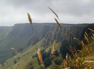
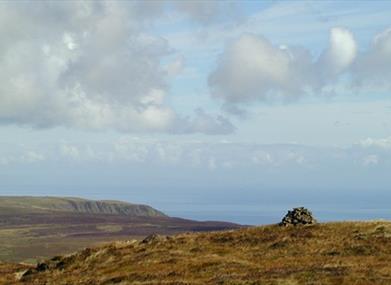
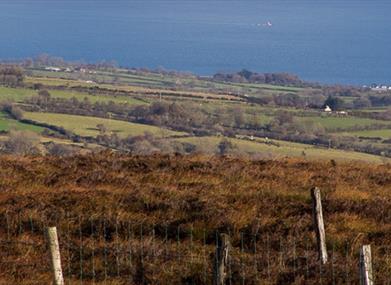
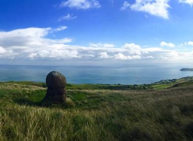
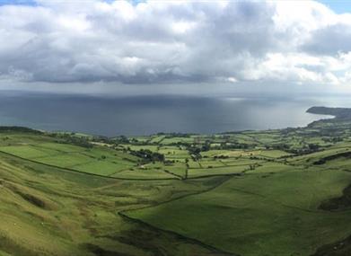
Section 2 - Black Hill to Mullaghsandall Road The route swings east at the summit of Black Hill, crossing rough, heather-covered ground towards the edge of the plateau. The coastal views improve as you progress, with the hills of Scotland and the rocky outcrops of the Maidens, or Hulin Rocks, all clearly visible out to sea. It’s an expansive panorama, and one that stays with you for the duration of the day. The terrain becomes easier underfoot as you head south along the eastern edge of the plateau. Keep to the high ground and cross a series of grassy undulations to arrive at the 378m summit of Scawt Hill. A gradual descent and ascent then brings you to the top of Ballycoos (361m). From here, descend easily across cropped grass to reach the road and car park at Linford. It’s worth pausing for a moment to examine the two prominent mounds near Linford car park, which are thought to be Neolithic burial sites dating from around 4000 BC. The route itself continues south, climbing around the impressive cliffline to reach a short section of stone track. Now pass over the shoulder of Robin Young’s Hill, and descend to heather moorland at the edge of Sallagh Braes. Follow a fence around the rim of the escarpment, with steep gullies allowing an occasional glimpse into the void below. The airy sensation and the view over the curving cliffs make this a very memorable piece of walking. A section of rough, peaty ground now brings you to the firmer surface of a farm track. Pass through a series of gates to reach Mullaghsandall Road. Did You Know? The coastal cliffs of all the hills on this route are a legacy of the last ice age. The most striking formation is Sallagh Braes, a semi-circular basalt escarpment that was created when glaciers cut into unstable slopes and caused a massive land slip. The cliffs of this natural amphitheatre are now some 100m high and 2km long.
Section 3 - Mullaghsandall Road to Donaghy's Bridge Head left along the tarmac for roughly 120m, then turn right onto a track enclosed by stone walls. You’ll need to cross a stream on stepping stones and negotiate two wooden gates before reaching open grassland. The posts now lead past an artificial lough, where you must cross another stream before climbing through a field to reach a road. Turn right and follow the road for almost 1km, with good views across the sheer eastern cliffs of Agnew’s Hill. This mountain presents the last challenge of the day, and the ascent begins as soon as you leave the tarmac. Climb steeply along the western side of the ridge, with a fence providing guidance on your left. Cross the fence near the top of the slope, and climb the final metres to the summit cairn. At 474m this is the highest point of the route, and an opportunity to survey your surroundings once again. From Black Hill in the north to Slemish in the west, almost the entire Antrim Hills Way is visible from here. Follow the ridge south and descend to a col. A brief final climb now brings you to the mountain’s southern cairn. This is where the route leaves the ridgeline and begins to head west. Descend gradually to a track that once formed part of an old droving road, and turn right. This part of the Antrim Hills Way finishes at the end of the track, at Donaghy's Bridge. If you have left a vehicle at Ballyboley Forest car park, follow the markers for the Ulster Way instead, passing through a section of forestry to reach the parking area. Did You Know? In 1595, the peak now known as Agnew’s Hill was marked on maps as ‘Benwellerorie’. Rory Ogue McQuillan was a prominent clan leader, and the name was an anglicisation of Binn Mhaol Ruairí , meaning ‘Rory's bare peak’. The modern name honours the Agnew family, who came to prominence after the decline of the McQuillans in the seventeenth century.
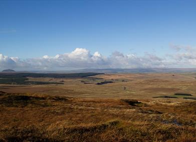
Section 4 - Donaghy's Bridge to Greenmount Hill Farm The second day of the walk starts near a wooden footbridge, where the track from Agnew’s Hill turns into a tarmac lane. A route information panel marks the spot. Parking is limited at the end of the lane however, so a better option is to leave your vehicle at Ballyboley Forest car park. From there, follow signs for the Ulster Way to reach this point. From Donaghy's Bridge, continue west along the lane. The first part of the road is little more than a track, with a healthy growth of grass splitting the centre of the tarmac. To your right lies an expanse of open grassland, while the dark boughs of a forestry plantation line the road to your left. When the trees drop back, long views open out along the Glenwherry Valley, with the windfarm at the top of Elliot’s Hill forming a prominent landmark. A gradual descent brings you to Crosswater Bridge. The grass has now abated and the road surface has consolidated underfoot. Keep straight ahead, still largely descending past several farms and houses. The noise of the traffic on the busy A36 begins to intrude as you near the end of the section. Continue past a row of mature beech trees, then a short distance later you arrive at the entrance to Greenmount Hill Farm and Agricultural College. The entrance to the farm is marked by a large sign for the ‘College of Agriculture, Food and Rural Enterprise’.
Section 5 - **Currently closed to members of the public**
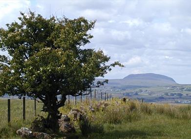
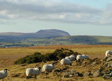
Section 6 - Shillanavogy Road to Slemish Cross directly over the Shillanavogy Road and begin to climb again on the other side. Rather than following a fence – as you have been doing for the last couple of kilometres – the route now heads northwest across open ground. A short ascent brings you to a prominent marker post on the northeastern slopes of Douglas Top. From here a new panorama is suddenly revealed, with the unmistakable profile of Slemish now visible to the northeast. This mountain owes its distinctive shape to the fact that it is an old volcanic plug, and was once constrained within the crater of a volcano. It will act as a beacon for the remainder of the route, beckoning you on to the finish. Descend northwest until you meet a track, then turn right. Follow the track downhill to a junction marked by a route information board. Now head left, continuing along another track to a prominent waymarker attached to a large, upright rock. Turn right at the rock and climb across two stiles to reach an expanse of rough heather and grass. A series of white-topped posts leads northwest across the moor, drawing ever closer to the steep, craggy slopes of Slemish. It is something of a relief to reach the cropped grass and firm ground surrounding Slemish itself. The trail skirts around the southwestern base of the hill, running just beneath a jumble of boulders. After almost a kilometre the car park comes into sight ahead, and a final descent beside a series of wind-sculpted hawthorns brings you to the end of the route. Did You Know? During the Tertiary period, this region was subject to two million years of intense volcanic activity. The remains of numerous extinct volcanoes dot the Antrim plateau, including Scawt Hill and Slemish. Both these mountains are made of dolerite, formed from hardened magma. Nearby formations such as the Giant’s Causeway also bear testament to the amount of lava that flowed. **During bird breeding season there can be diversions in place. Please follow any signage on site**
Please be aware that this walking route passes through areas of open land such as hillside, working farmland and working forests. Livestock and bulls can be present at certain times of the year, ground conditions may be uneven or wet underfoot and all forestry signage should be adhered to.
Distance:
22 miles
Terrain:
Ueven, hilly and usually wet
Points of interest:
Spectacular views of Slemish and the coastline.
Facilities:
Toilets are at Glenarm, Larne town and Slemish. Refreshments will be at Glenarm, Larne, Broughshane and Ballymena.
Nearest town:
Glenarm
OS map:
Sheet 9
Accessible toilet facilities:
Yes
Accessible terrain:
Accessible toilets in Glenarm Village and at Slemish. Most of the walk is off road - this includes very wet sections and uneven surfaces.
Accessible signage:
Information panels are located at Glenarm car park and Feystown Road points. The route is marked by posts.
Book Tickets
Facilities
Provider Preferences
- Free (parking charges may apply)


